The following extracts, which contain references to Fernhill Farm, are taken from an article on the
British History Online website, entitled
The borough of Warwick: The castle and castle estate in Warwick. Apart from the town of Warwick itself, the land of the Warwick estate was roughly divided into three areas: Wedgnock Park, the Temple Manor and Castle Park. References to the earl are to the Earl of Warwick, who for the purposes of this thread was
Leopold Greville, 6th Earl of Warwick"In 1819 the earl's court baron was hearing presentments of encroachments in the shape of steps, railings or porticoes projecting into the streets, which were regarded as the waste ground of the manor. (fn. 257) The jury at the same court set out the bounds of the manor, showing that it included the whole of the parishes of St. Mary and St. Nicholas as well as land in Budbrooke, Hatton, and Beausale formerly in Wedgnock Park. (fn. 258)
[
]
WEDGNOCK PARK
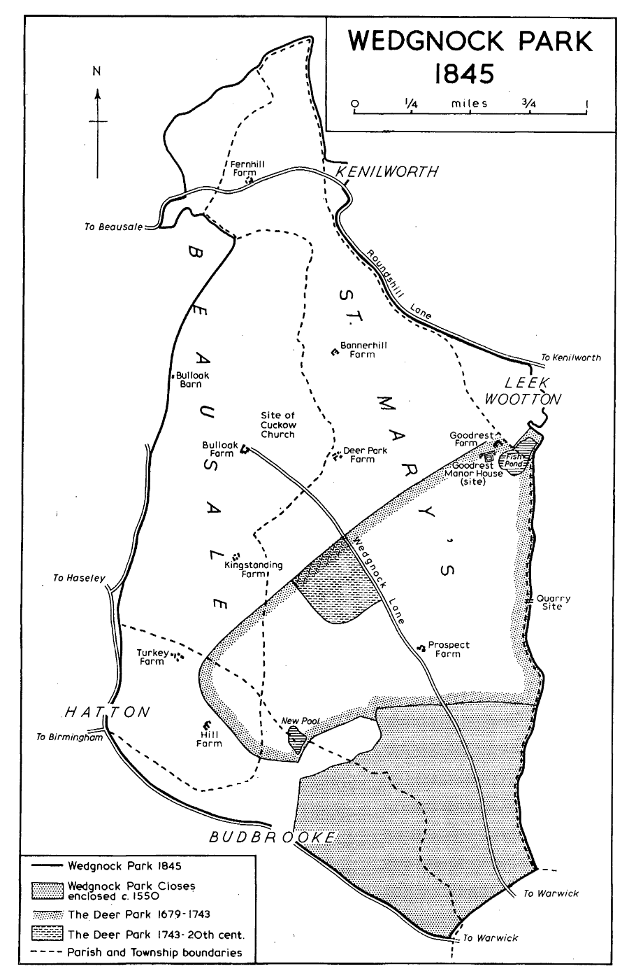
The dimensions of Wedgnock Park were set down in 1845 at the time of tithe commutation, when it was held to contain 2,831 acres, made up of 1,556 acres in St. Mary's parish, 726 acres in Beausale, 203 acres in Hatton, 278 acres in Budbrooke, 41 acres in Leek Wootton, and 27 acres in Kenilworth. Only 42 acres were then in use as a deer park. The shape of Wedgnock Park was an irregular diamond, about 4 miles by 1¾, extending from the canal bridge on the Birmingham road (formerly called Wedgnock Lane) northwards to Fernhill, and from Catchems End on the south-west to Goodrest Farm on the north-east. (fn. 300) The boundary of the manor of Warwick north of the town coincided with that of the park, and the 'Duchy bank', which the jury in 1819 regarded as the manorial boundary for long stretches, (fn. 301) could be recognised in 1965 as the bank on which the park pale stood, most apparent where it crosses and recrosses Roundshill Lane.
[
]
In 1601 the Privy Council instructed the surveyor for the county, and others, to value the park, exclusive of the herbage, pannage and fishing already let. They answered that 500 deer of all kinds had ordinarily been kept there, and not more 'for that the whole park is a sour ground, and the situation of the greatest part thereof is low and much subject to water, and the higher ground overgrown with shrubs'. If disparked, they thought the ground worth £50 in excess of the herbage. (fn. 354) To answer a further enquiry concerning Fernhill, sometimes described as part of the park and sometimes said to adjoin it, they took the evidence of an aged inhabitant who remembered deer there and a pale about it with deerleaps out of Honiley into Fernhill and out of Fernhill into Wedgnock Park. The pale between Fernhill and the park was only a 'footset pale' with no bank, and was thought to have originated when the king's stud was in Fernhill. One of the keepers had charge of Fernhill as part of his walk, and looked after the stud at that time as well as his deer. (fn. 355) The corporation of Warwick, as patrons of the rectories of St. Mary's and Budbrooke, had 13s. 4d. as tithe of the herbage, with two bucks and two does as tithe of the park yearly, and also pasturage for six oxen in the park, valued at £4, for repair of Wedgnock Lane. (fn. 356) Following this survey, Sir Fulke Greville received in 1602 an outright grant of the park, including Fernhill, Goodrest, and the three gamekeepers' lodges, but excluding the inclosures held of the Crown by other tenants, paying yearly the tithe bucks and does and £4 to the corporation and £66 13s. 4d. to the Exchequer. (fn. 357) The disparked inclosures at the southern end of the park descended with the manor of Warwick to the Bolton family. (fn. 358) In 1652, under the name of Wedgnock Park Closes, they contained 435 acres divided into 75 closes between nineteen tenants. (fn. 359)
[
]
Between 1679 and 1682 all the north and west parts of the park were inclosed. New farmhouses were erected on the sites of the present Hill Farm, Turkey Farm, Bulloak Farm, and Deer Park Farm, and on a site close to Fernhill Farm but south of Roundshill Lane. Barns were placed where Bannerhill Farm and Bulloak barn now stand. Goodrest manor-house and a lodge, perhaps that built by Thomas Fisher in 1560, remained within the deer park which also contained a round copse of 20 acres. (fn. 369)
[
]
A large part of Fernhill wood was grubbed up in 1789 and new farm buildings were begun there in 1793. (fn. 370) The last part of this ancient wood was removed by the tenant of the farm in about 1935. (fn. 371)
Footnotes.
257 Kemp, Hist. Warw. 267-8.
258 Ibid. 269-72.
300 Rowington par. recs. C.R.O., N 5/142.
301 Kemp, Hist. Warw. 269-72.
354 L.R. 2/257 f. 172.
355 Castle MS. 2563.
356 L.R.2/257 f. 172.
357 Castle MS. 2561.
358 Ibid. 6128.
359 Ibid. 9204.
369 Castle estate map, 1682.
370 Castle accts. and vouchers, and estate maps, 1750, 1788.
371 Ex inf. Mr. Walder of the Castle Estate Office.
